 |
| Whether you prefer the term Richat Structure, Earth’s bulls-eye, or Eye of Africa, it’s interesting and it looks pretty cool from above the Sahara Desert. |
 |
| Not being an astronaut and all, I had no idea that the Earth had a bulls-eye or that Africa had an eye in the desert that can be seen from space. |
 |
| Geologically, this anticline is a fold in the Earth, rock layers exposed by hot desert winds. The oldest rock beds at at its center core, with younger rocks in the outward circular form. |
 |
| Zooming in closer to observe the Earth’s bulls-eye – Richat Structure, Oudane, Mauritania. |
 |
| From Google maps, drawing closer to the Eye of Africa. |
 |
| The Eye of Africa as seen from Google maps – starting out far and moving closer to the Richat Structure, Oudane, Mauritania. |
 |
| There are some people who try to attribute the Richat Structure in Oudane, Mauritania, as being lasered into the Earth by aliens. |

 |
| Do you have 3D glasses handy? You need 3D glasses to really appreciate this Anaglyph Landsat Image shot of Richat Structure, Mauritania. |
 |
| Mauritania – Sahara Desert in Africa – the Earth’s Bulls-eye |
 |
| NASA wrote, “This prominent circular feature in the Sahara desert of Mauritania has attracted attention since the earliest space missions because it forms a conspicuous bull’s-eye in the otherwise rather featureless expanse of the desert. Described by some as looking like an outsized ammonite in the desert, the structure [which has a diameter of almost 50 kilometers (30 miles)] has become a landmark for shuttle crews. Initially interpreted as a meteorite impact structure because of its high degree of circularity, it is now thought to be merely a symmetrical uplift (circular anticline) that has been laid bare by erosion.” |
 |
| NASA explained, “The Richat Structure in the Sahara Desert of Mauritania is easily visible from space because it is nearly 50 kilometers across. Once thought to be an impact crater, the Richat Structure’s flat middle and lack of shock-altered rock indicates otherwise. The possibility that the Richat Structure was formed by a volcanic eruption also seems improbable because of the lack of a dome of igneous or volcanic rock. Rather, the layered sedimentary rock of the Richat structure is now thought by many to have been caused by uplifted rock sculpted by erosion. The above image was captured last year by the orbiting Landsat 7 satellite. Why the Richat Structure is nearly circular remains a mystery. |
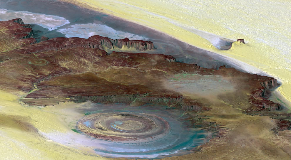 |
| This prominent circular feature, known as the Richat Structure, in the Sahara desert of Mauritania is often noted by astronauts because it forms a conspicuous 50-kilometer-wide (30-mile-wide) bull’s-eye on the otherwise rather featureless expanse of the desert. Initially mistaken for a possible impact crater, it is now known to be an eroded circular anticline (structural dome) of layered sedimentary rocks. |
Tidak ada komentar:
Posting Komentar